 |
 |
|
|
|
PRESENTATION
Numerical models are frequently used for the simulation of pollutant
dispersion within the urban canopy layer. Complex numerical tools
for urban dispersion modeling have been developed during the last decade
and most of them prove themselves as a more or less perfect representation
of reality in terms of the quality of physical modeling of scalar transport
phenomena as well as of the quality and accuracy of the model results.
On the other hand, comparisons of model results with independent field
data or results of physical dispersion modeling in boundary layer wind
tunnels still show significant discrepancies in the results of a numerical
simulation and physical reality. Searching for what is causing those
differences one has to subdivide the problem into two major categories
of error sources. One group is represented by differences due to
the simplified physics implemented in numerical models. There is
still a lack of information on urban scale turbulence, wind fluctuations
in complex urban areas as well a gap in knowledge on how to model turbulent
dispersion within the urban canopy layer. Fortunately, systematic
validation and refinement of numerical models, made possible by high quality
reference data, may result in a further improvement of the quality of the
model physics, which is dominated by the accuracy of turbulence modeling.
The second group of differences obviously is caused by differences in the
geometrical representation of the physical reality due to discretization.
Most of the numerical dispersion models available use a box-type representation
of buildings for resolving limited areas of an urban roughness. As
a result, all buildings may have flat roofs instead of the variation in
roof configurations in the original. In addition, building dimensions
are adapted to the more or less dense numerical grid, causing significant
differences between the full scale building dimensions and the numerical
representation. Moreover, an essential number of buildings might
not be well aligned with the regular structured grid that is commonly used
in practical dispersion models. Subsequently, for oblique street
canyons the surrounding buildings are represented by step-like structures
that might clearly affect the flow. It is obvious, that the uncertainty
caused by geometrical simplification of the physical reality may play an
important role in assessing the quality of results from numerical modeling.
Even if the physics of numerical modeling might be improved in the
foreseeable future, significant geometrical simplifications will be required
for practical application of numerical modeling. Therefore, it is
important to visualize and quantify the uncertainty of results inherent
in every box-type numerical model in order to avoid overrating the results
of numerical dispersion modeling.
The presented study gives an introduction in how physical modeling might
be used for quantifying effects of geometrical simplification. Based
on the results of wind tunnel measurements from several physical models
with different complexity and geometrical abstraction, the basic effects
of changing the representation of buildings are documented.
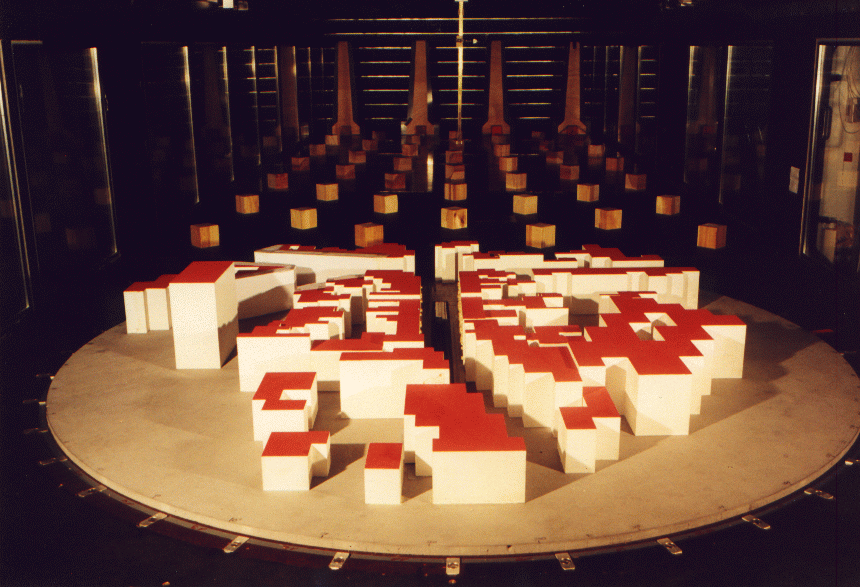
Several models directly adapted from numerical grids which were used
for flow and dispersion simulations have been tested in the multi-layer
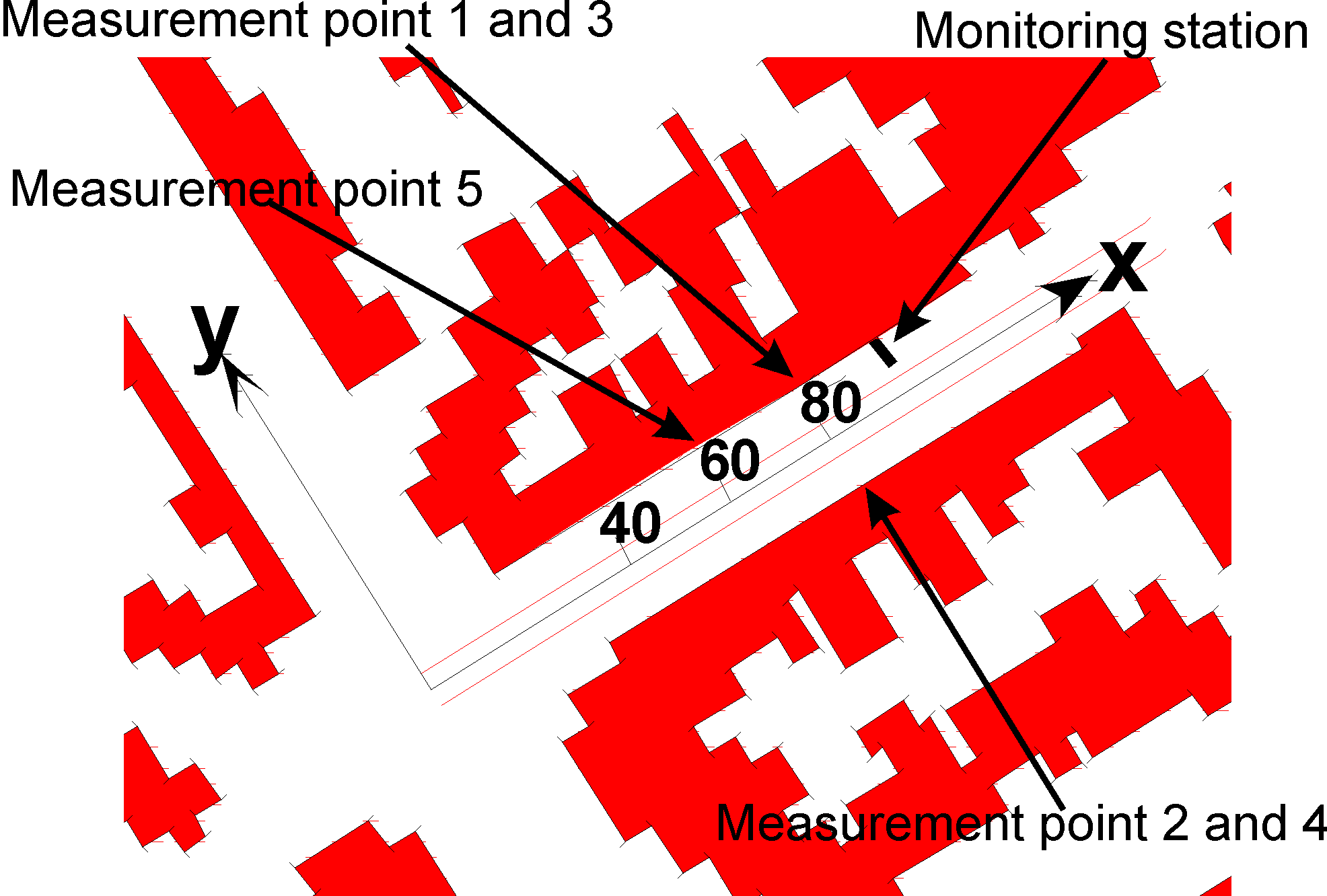
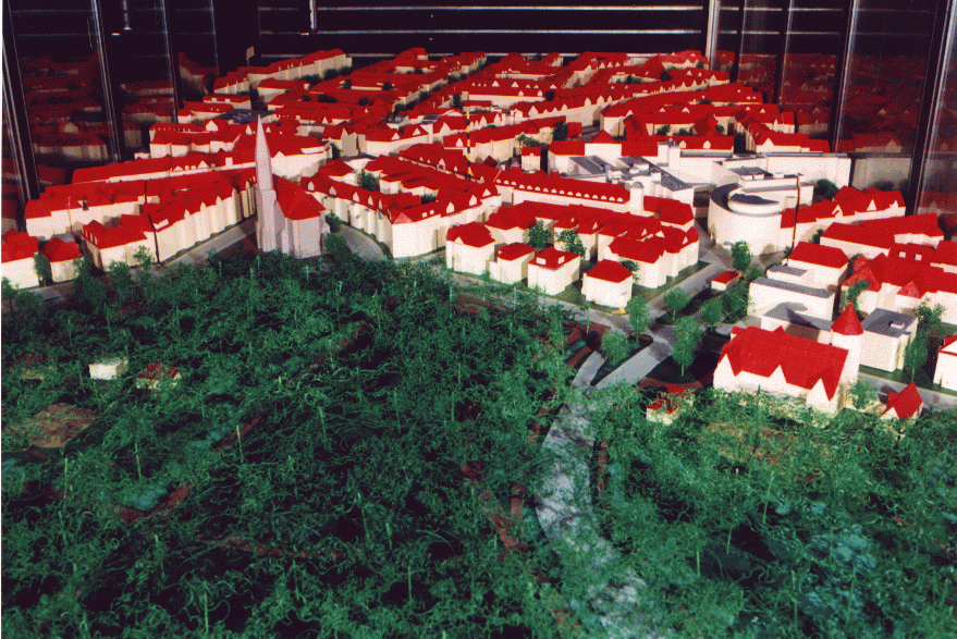
wind tunnel at the University of Hamburg, Fig. 1a and 1b show a simplified
as well as a more detailed model representation of the "Podbielski Strasse"
field site in Hanover.
|
|
|
|
|
|
 |
|
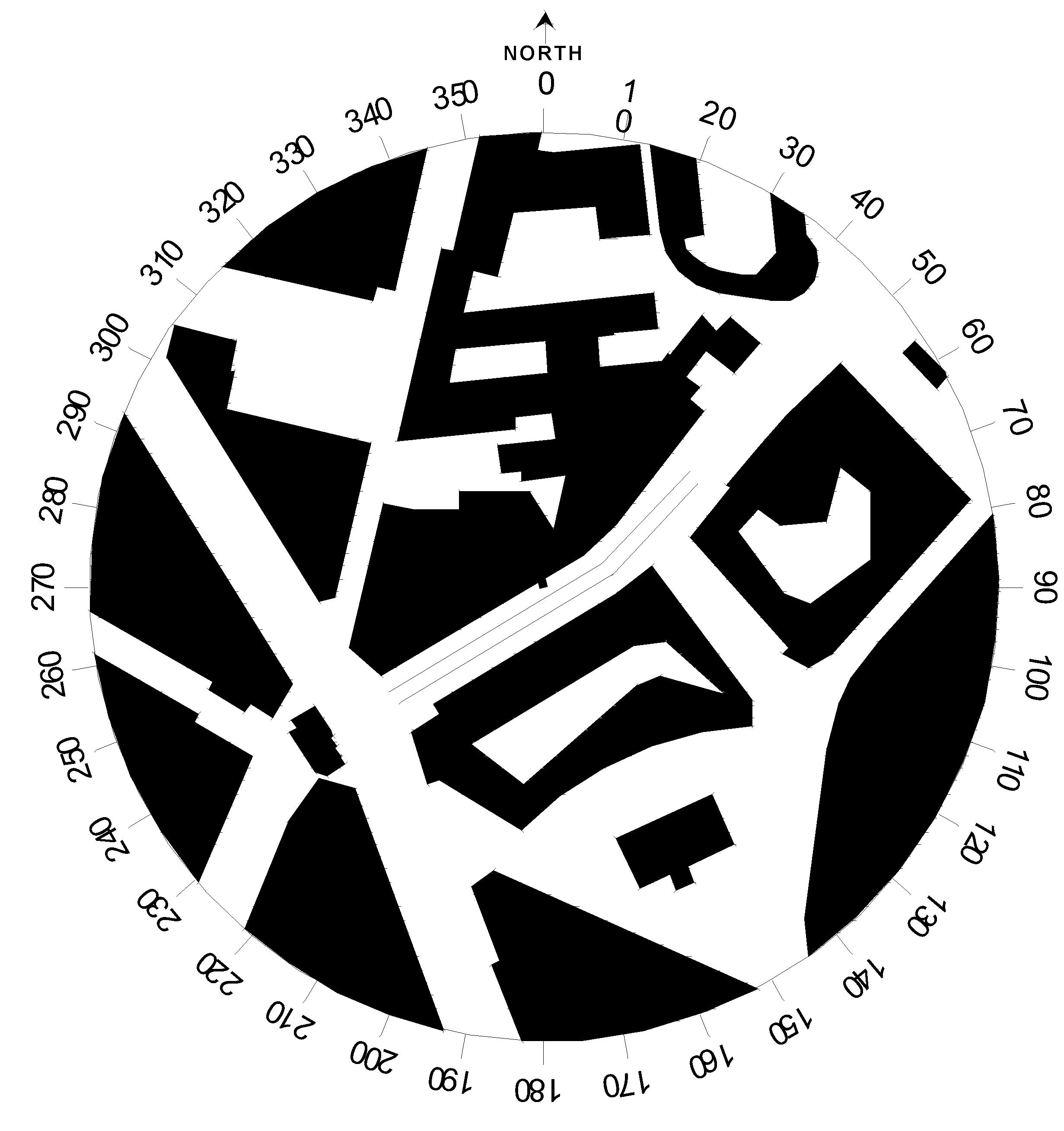
Figure 2c: detailed model sketch
The following table presents the exact measurement point location according to the coordinate system defined on the figure 2b.
|
|
|
|
|
|
|
|
|
|
|
|
|
|
|
|
|
|
|
|
|
|
|
|
|
|
|
|
|
|
Measurements were carried out at several
locations in all different models. Mean values of the emission time series
recorded were acquired for a total of 36 wind directions {0...360 in steps
of 10), from all results the background concentrations of tracer have been
subtracted before they were scaled to a non dimensional c* for comparison
with field data and results from numerical simulations. We defined the
non dimensional concentration c* like :
 |
c : the concentration measurement in wind tunnel
Uref: reference wind speed at 0.5m from the ground (100m high in field), H : reference building high 0.125m (25m in field), L : effective line source length, Q : Ethan flow in the line source. |
RESULTS
Typical c* over wind direction plot for two different models used is
given in Figures 3 to 8.
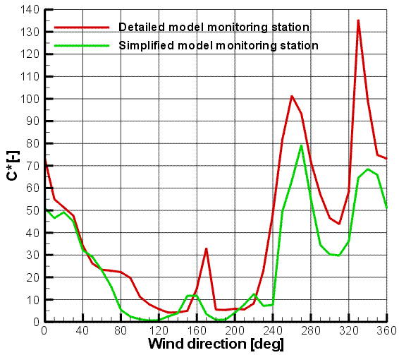
Figure 3: Pollutant dispersion over wind direction for the monitoring
station
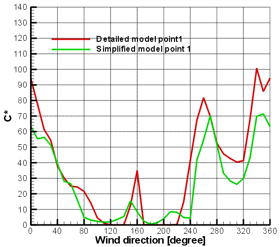
Figure 4: Pollutant dispersion over wind direction for point
1
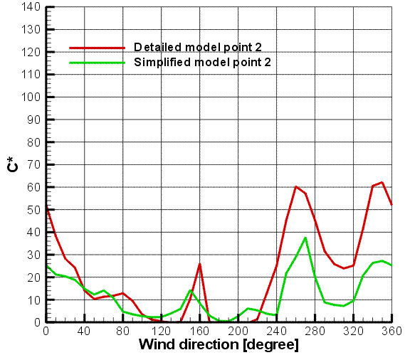
Figure 5: Pollutant dispersion over wind direction for point
2
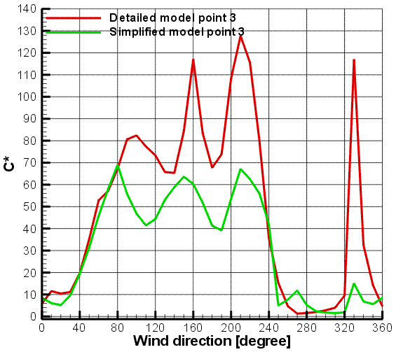
Figure 6: Pollutant dispersion over wind direction for point
3
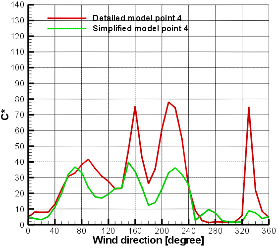
Figure 7: Pollutant dispersion over wind direction for point
4
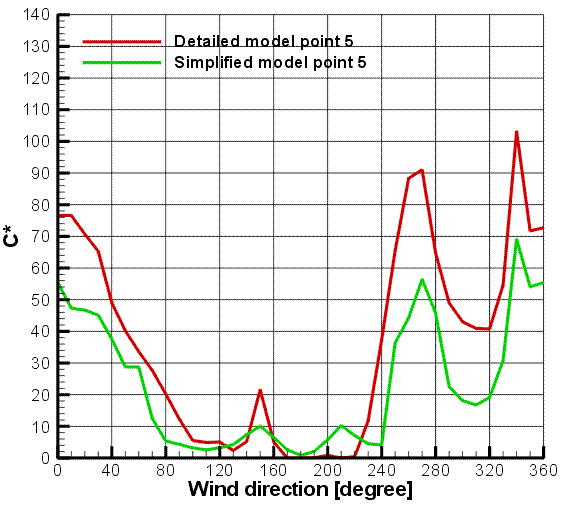
Figure 8: Pollutant dispersion over wind direction for point
5
By comparing results from detailed physical modeling as well as results
from simplified models with different levels of abstraction one can quantify
the inherent offset in results from simplified modeling. In addition
simplification in modelisation can hide some pollutant pick.
Searching for what is causing the general offset, systematic investigation
were done by modifying the simplified model. The effect of the step
structure in the surrounding oblique street were quantified in the both
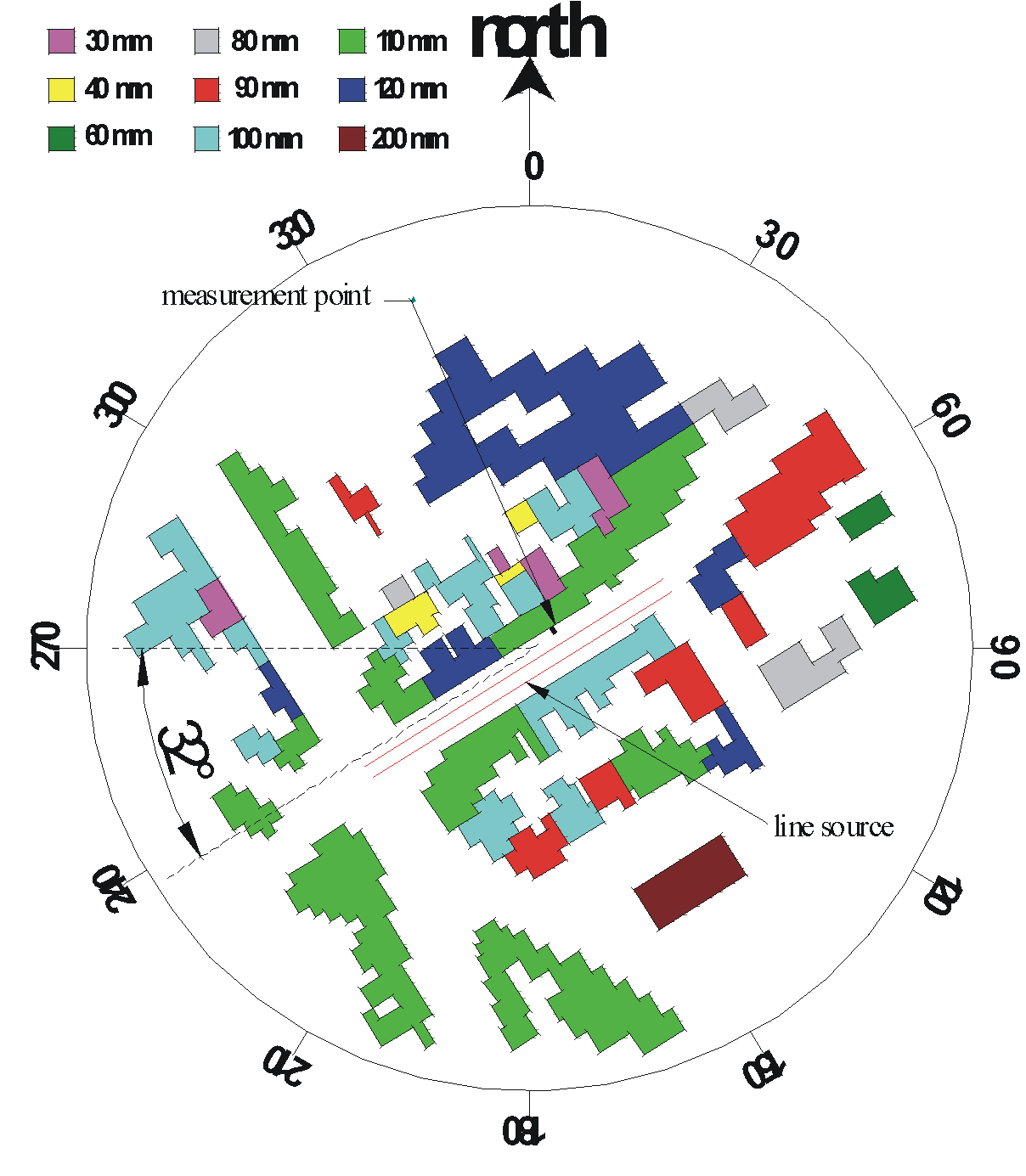
model Jagtvej and Podbelski. The figure 9 presents the modification made
on the Podbielski model. The effect of roughness within the street canyon
were also investigated, by adding architectural details on the wall to
simulate the balconies for instance, or by adding roughness on the ground
to study the effect of the blockage induced by the car. The numerical
modeler can only simulate flat roof building. To quantify this effect,
slanted roof were added in the Jagtvej model. In this case two effects
were cumulated, the slanted roof effect and the building height increase
(cf. Jagtvej pollutant measurements for more
details about slanted roof effect). The figure 10 and 11 present the results
for the monitoiring station measurement point and for the measurement point
3.
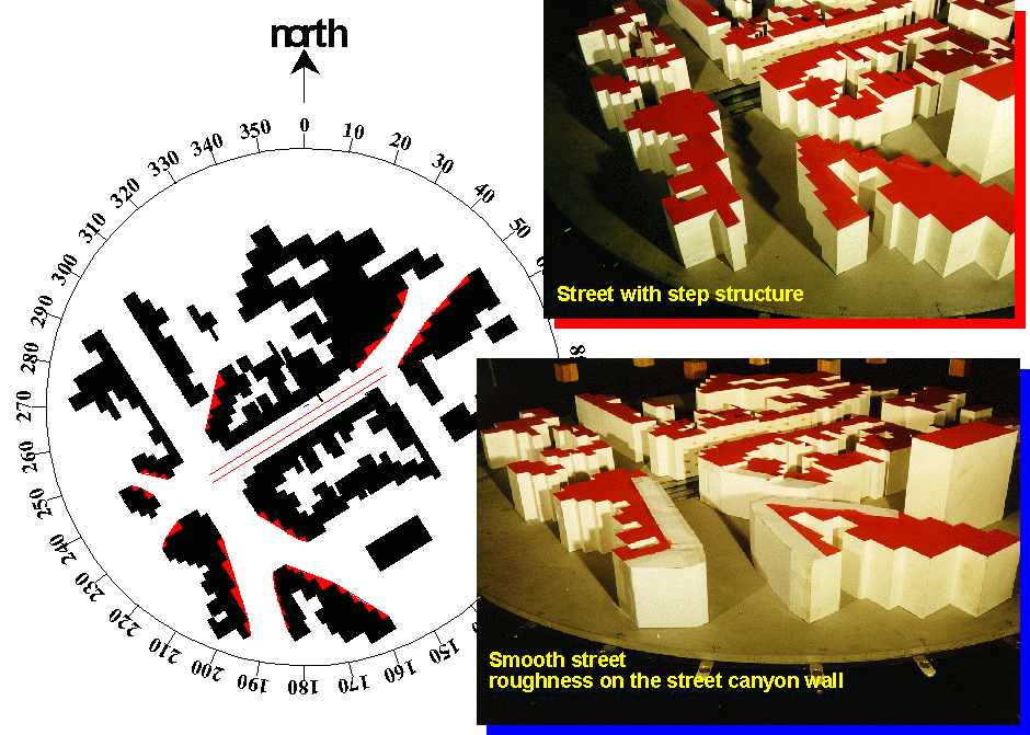
Figure 9: step structure modifications
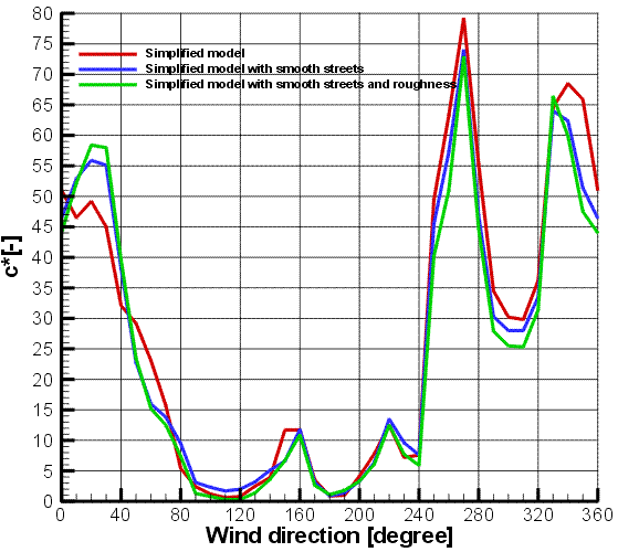
Figure 10: monitoring station measurement point
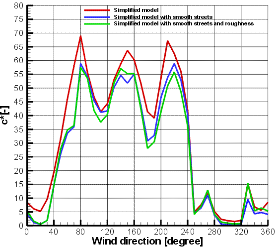
Figure 11: measurement point 3
CONCLUSION
The presented study gives an introduction in how physical modeling
might be used for quantifying effects of geometrical simplification.
Based on the results of wind tunnel measurements from several physical
models with different complexity and geometrical abstraction, the basic
effects of changing the representation of buildings are documented.
A systematic investigation was made to quantify the effect of simplification
due to the discretization on the model used for the numerical simulation.
A general offset was observed for the wind direction where the pollutant
concentration was significant. Searching for what is causing this
difference, an investigation of this effect of modification on the simplified
model was done. The results showed an influence off all parameters,
but no one had a major effect. The important difference observed
between pollutant dispersion measured on a detailed model and a simplified
model was a combination of all the studied aspect.
Request further informations on the measurements, please contact Prof Schatzmann